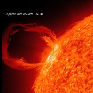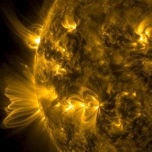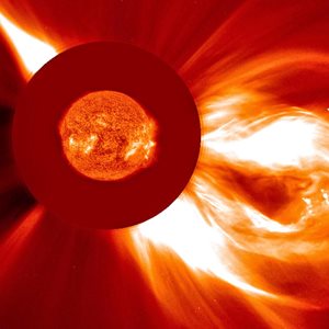
Space weather describes variations in the environmental conditions of near-Earth space that are largely caused by radiation, energetic particles and plasma emitted by the Sun. These solar emissions interact with the Earth’s geomagnetic field and upper atmosphere to produce a variety of physical effects and technological impacts. Space weather variations occur all of the time, minor storms are relatively common and a major storm may occur once or twice per decade. Solar superstorms occur once every one hundred to two hundred years.
Space weather monitoring
The most recognisable and visible space weather effect is the aurora, commonly known as the Northern and Southern Lights. Aurora normally occur in polar latitudes, however, during very severe space weather they may be seen at low latitudes, for example in the Caribbean and Hawaiian Islands. This is what happened in 1859 when a huge solar flare occurred and an associated major coronal mass ejection reached the Earth.
How does space weather impact life on Earth?
 Space weather forecasts are not normally featured in every day news bulletins and consequently go largely unrecognised by the general public. However, space weather has to be accommodated in the design and operation of an increasing number of modern technological systems. For example high energy particles associated with space weather can cause satellite failures and space weather can cause satellite based navigation systems, which we all use every day on our mobile phones, to be become less accurate. Other impacts are experienced on the electricity grid, satellite and cellular communications systems, communications to aircraft, avionics, and air passenger and crew safety. Looking to the future, space weather will be a major hazard on manned missions to Mars.
The impact of space weather on all of these systems will be much more significant during a solar superstorm with consequences for the national infrastructure, UK industry and the wider public. As a result, in 2011 space weather was added to the Government National Risk Register of Civil Emergencies. The likelihood is currently judged to be comparable to that of an emerging infectious disease. Only by providing sufficient advance warning, and having robust plans in place for reacting to an extreme event, can we be confident of minimising the consequences.
What are we doing to provide solutions to the problems posed by space weather?
Professor Paul Cannon and Dr Sean Elvidge have had a pivotal impact on the development of UK and global policies and strategies to mitigate and respond to extreme space weather.
In 2013, distinguished University of Birmingham scientist Professor Paul Cannon led a major study for the Royal Academy of Engineering to clarify the impacts of extreme space weather on our engineered systems and infrastructure. The report outlined the actions the UK should take to mitigate the effects of this relatively rare but potentially serious event.
Extreme space weather: impacts on engineered systems and infrastructure report (pdf - 1.3 MB)
The report provided information to government that supported the creation of the Met Office Space Weather Operations Centre. This now provides round-the-clock forecasts to help protect the country from the threats posed by severe space weather and also manage day-to-day space weather forecasts. The report also energised government to initiate appropriate risk reduction programmes and these are supported by a number of domain specialists from UK universities and national research laboratories.
 Professor Paul Cannon was also a leading proponent of a proposal to UKRI to fund a £20m Space Weather Instrumentation, Measurement, Modelling and Risk (SWIMMR) programme, which seeks to boost the UK Met Office’s ability to forecast space weather.
SWIMMR started in June 2020 with the University of Birmingham’s Space Environment and Radio Engineering (SERENE) Group, led by Dr Sean Elvidge as the Principle Investigator on two NERC funded projects (total value £3.7M) that seek to provide better ionospheric and thermospheric forecasts. The Birmingham-led consortium draws together UK experts in upper atmosphere modelling from the Universities of Bath, Lancaster, Leicester and Leeds together with the British Antarctic Survey.
Much of this new research will be underpinned by ground-breaking data modelling techniques developed at the University of Birmingham, which can predict atmospheric space weather with unprecedented speed and accuracy. The projects will tackle two major space weather engineering challenges. Firstly, minimising collisions between satellites and other satellites and satellites and space debris; and secondly maintaining and improving the precision of satellite based navigation systems and communication to aircraft during challenging space weather.
Space weather monitoring to get major upgrade in new research programme
Space Environment and Radio Engineering (SERENE) Group
The SERENE group seeks to bridge the gap between academia and industry and has strong links with Dstl, the UK Met Office, QinetiQ and the European Space Agency as well as traditional UK Research Councils, primarily NERC and EPSRC.
 The group has a number of active research themes, including Over The Horizon Radar (OTHR), space radar, and the impacts of scintillation on satellite communication systems.
The primary research focus of SERENE is, however, modelling. SERENE has developed an operational first-principles data assimilation model of the Earth’s ionosphere and thermosphere, that uses state-of-the-art mathematical techniques coupled with tens of thousands of globally distributed observations to make accurate and actionable real time space weather forecasts.
SERENE also investigates the long-term likelihood of extreme space weather events, which it does using statistical methods, to estimate the associated risks. This enables the UK Government to better evaluate this risk in comparison to other risks.
Images: NASA. From top to bottom of page: detail of Solar Dynamics Observatory (SDO) image of the Sun taken at a wavelength of 17.1 nanometres; Coronal loops, gigantic loops of magnetic field, beginning and ending on the Sun's visible surface; Solar Dynamics Observatory (SDO) image of the Sun taken at a wavelength of 17.1 nanometres; and a coronal mass ejection (CME) as seen by the Solar and Heliospheric Observatory (SOHO) satellite mission