Motivation
It is estimated that in the UK alone we spend over £7 billion annually on streetworks . A large share of this cost is induced by uncertainty or lack of knowledge of location and condition of our underground assets. There are numerous cases where exact position and/or condition of buried assets and their supporting ground are extremely challenging, if not impossible, to determine using current remote sensing technologies. This can unnecessarily prolong the streetworks, lead to damages to the assets or even fatal injuries.
Performance of the available techniques is susceptible to the burial condition of the pipe, e.g., type and physical properties of the soil, burial depth, ground composition, and material of the pipe. Above all, existing techniques for condition assessment of underground utilities fail to capture a complete picture of the ground-utility symbiotic interaction and cannot provide information on the structural integrity of buried infrastructure and their supporting ground.
At the same time, routine and effective condition assessment of buried utilities as well as roads and railways can significantly reduce the probability of failures caused by deterioration and therefore is of significant financial and strategic importance and allows better resources planning.
A novel approach with clearly defined advantages in certain burial conditions, alongside available techniques, provides a more versatile, inclusive, and reliable toolbox for the detection and condition assessment of buried pipes.
Approach and aim
The focus of the GUIDE project was to develop a novel, non-expensive, yet very accurate method to both locate buried utilities and assess the condition of the utilities and their supporting ground.
Methodology
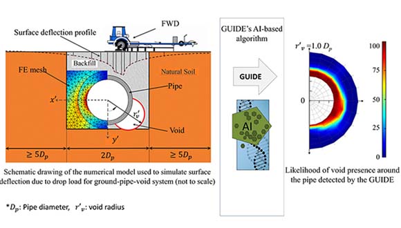
The proposed method uses ground deflections caused by a drop load to back-calculate the stiffness of the system. Here the word system refers to the integrated ground and buried utilities. The back-calculation procedure of the GUIDE is an optimisation procedure that uses i) finite element models of the ground and buried infrastructure to accurately capture the condition of the system and ii) a machine learning algorithm to estimate the location and condition of the buried asset based on the surface deflections. Figure 2 illustrates the two phases of the GUIDE back-calculation, i.e., finite element modelling and genetic algorithm-based machine learning. The proposed back-calculation approach can address the complex environment of underground surface, and soil-asset interaction. Through a set of laboratory experiments and numerical modelling, the GUIDE successfully demonstrated the benefits of the proposed approach in both locating and condition assessment of buried pipes. Large-scale experiments in the National Buried Infrastructure Facility (NBIF) and field trials are planned to be conducted in near future to establish the extent in which the proposed method can be used.
 Image: an overview of the GUIDE procedure